REDD+ Carbon Standards Compared: Verra VM0048, ART TREES and the Alternatives
Compare REDD+ and forest conservation standards (Verra VM0048, JNR, ART TREES, Plan Vivo, Climate Action Reserve, BioCarbon, Cercarbono and Equitable Earth) by baseline, monitoring and ICVCM status.
REDD+ projects earn credits for forest that stays standing: avoided deforestation, avoided degradation and forest conservation. The rules changed more in the last three years than in the decade before. Verra now sets project baselines itself, governments are registering whole jurisdictions, and buyers ask which credits carry the ICVCM label.
This guide compares the standards that certify REDD+ and conservation projects, by who sets the baseline, what you monitor and what your field team has to keep. It compares published rules, not outcomes, and is not legal or investment advice. First-party documents checked October 18, 2026.
Compare REDD+ standards
| Standard | Methodology | Scale | Who sets the baseline | ICVCM label |
|---|---|---|---|---|
| VM0048 with module VMD0055, for avoided unplanned deforestation | Project; nested where a jurisdictional program exists | Verra's data providers, who allocate deforestation from a jurisdiction-wide risk map | Approved, with VMD0055 v1.1 | |
| Jurisdictional and Nested REDD+ framework | Jurisdiction, with or without nested projects | The jurisdiction's reference level | Approved (v4.1) | |
| TREES 2.0 and 3.0 | National, or one government level below | The jurisdiction's five-year historical average, lowered each period | TREES 2.0 approved, except high-forest, low-deforestation and removals; TREES 3.0 not yet assessed | |
| PM001 with module PU002, forest protection | Community and smallholder projects | Projected historical deforestation in the project or matched control areas | Not listed | |
| US Forest Protocol, avoided conversion | US forests under a conservation easement or public transfer | An appraisal showing a legal alternative use worth more than the forest | Not listed for avoided conversion | |
| BioCarbon Standard | BCR0002, avoided unplanned deforestation and degradation | Project | A reference region with similar trends, over 10 years of history | Not listed |
| Cercarbono | M/LU-REDD+ v3.1 | Project, grouped, jurisdictional or nested | Consistent with the country's forest reference level | Under assessment |
| Equitable Earth | M002 v1.0.2, avoided unplanned deforestation and degradation | Project, nested in a jurisdiction Equitable Earth has mapped | Equitable Earth, from a jurisdictional reference level allocated by risk map | Under assessment |
Gold Standard does not credit avoided deforestation. ICVCM is also assessing two newer conservation methodologies: ACR's Active Conservation and Sustainable Management on US Forestlands, and Equitable Earth's Terrestrial Forest Conservation. Status from the
ICVCM assessment page.
What changed with VM0048
Under the older methodologies, each developer drew its own reference region and projected its own deforestation. Under VM0048, Verra's contracted data providers map deforestation risk across the whole jurisdiction, and each project receives the share that falls on its area and its leakage belt. The project supplies the carbon stocks of its own forest. It can't bring its own risk map, though anyone can submit data for the providers to consider.
What this means in practice:
- One activity so far. VM0048 works through modules, and only the one for avoided unplanned deforestation (VMD0055) exists. Modules for planned deforestation and degradation are still to come.
- Data you buy. Free 100-meter maps are for project design. Registration needs Verra's higher-resolution data, bought through the Verra Project Hub. As of May 1, 2026, that data covered five Brazilian Amazon states, Peru, Cambodia, Colombia and the Mai-Ndombe province of the Democratic Republic of the Congo (
data table).
- Baselines on a cycle. The allocated baseline follows the jurisdiction's period, six years under VMD0055 v1.1, and carbon stock plots are remeasured when it is reassessed. Verra published corrections to the module in May 2026, so read them with it.
- A deadline for older projects. VM0007 and VM0015 are still active, and VM0009 was inactivated in November 2023. A registered project avoiding unplanned deforestation generally switches to VM0048 at its first verification after its region's risk map has been out for six months, with some leeway for verifications already under way (
What each standard asks you to monitor
| Standard | Forest loss | Carbon stocks | Cycle |
|---|---|---|---|
| A stratified sample of points read on imagery of 10 meters or finer, in the project and its leakage belt; field checks optional | Field plots, remeasured when the baseline is reassessed | At least every five years or before each verification; a household survey on who is clearing forest before each baseline period, or a conservative default instead | |
| Maps or sample-based area estimates for the whole jurisdiction | Emission factors re-evaluated every five years | Five-year crediting periods; verification after years 1, 3 and 5 | |
| Land-cover change in the project area | Emission factors for each land-cover class | Annual reports | |
| The easement or transfer keeps the land in forest | Forest inventory | Annual monitoring reports; a site visit at the start, then at least every 6 reporting periods, or 12 for small projects, with conditions; 100 years of monitoring | |
| BioCarbon Standard | Forest cover and degradation by satellite every year; fires, patrols and incidents as they happen | Field plots, national inventory or LiDAR every five years | Baseline reassessed every five years, or sooner if deforestation departs from it by more than 20% |
| Cercarbono | Land-cover change by remote sensing every year, with georeferenced field checks | Plots or calibrated remote sensing | Annual map consistency review |
| Equitable Earth | Satellite alerts checked against Sentinel or Landsat, run by Equitable Earth | Satellite biomass maps, plus your field assessments at the start and every 5 years | Baseline reset every 5 years; verification every 1–5 years; annual reports |
Sources: VMD0055 v1.1 and its
May 2026 corrections,
TREES 3.0,

US Forest Protocol,
BCR0002,
Cercarbono REDD+ v3.1.
Where each standard fits
 Verra VCS
Good fit: Project developers in a jurisdiction where Verra's compliant data already exists, selling to buyers who want the ICVCM label.
Plan for: A baseline you don't control, and data you pay for. A landowner who leaves the project takes their area's past credits with them, so parcel-level boundaries and agreements matter from the start. VCS version 5 adds consent and benefit-sharing rules, most of them from January 1, 2027.
Verra JNR
Good fit: Governments building a jurisdictional program, and projects inside one. Verra's framework supports a jurisdiction-only program, a jurisdictional reference level with nested projects, or a full program with nested projects.
Plan for: A VM0048 project inside a registered JNR program must nest in it. Where local rules require, a project must also cap its credits at a lower government baseline.
 ART TREES
Good fit: National governments, or states and provinces one level below, with at least 2.5 million hectares of forest for subnational accounting. TREES 3.0 adds a route for governments to register areas made of recognized Indigenous territories, with a lower minimum for them.
Plan for: ART does not credit projects. How projects take part is the government's decision. Credits from the optional high-forest, low-deforestation level carry no ICVCM label yet: in April 2026 ICVCM asked ART to take remedial action first, and ART requires a 20-year commitment before they could qualify.
 Plan Vivo
Good fit: Community forest protection, where the people protecting the forest are the project. PM001 covers forest protection through its PU002 module, alongside planting and agroforestry. Plan Vivo requires consent and a 20% risk buffer, and at least 60% of credit-sale income goes to benefit participants and other local stakeholders over the crediting period.
Plan for: No ICVCM label for its methodologies yet, and a smaller market than Verra's.
 Climate Action Reserve
Good fit: US forest owners who can put a conservation easement on land that faces a real threat of conversion. A certified appraisal has to show a legal, suitable alternative use worth at least 40% more than keeping the forest.
Plan for: 100 years of monitoring after the last credits are issued. The Mexico Forest Protocol has no avoided-deforestation activity; it is designed to complement jurisdictional REDD+.
BioCarbon Standard
Good fit: Projects in Latin America that want a project-level baseline from their own reference region. BCR0002 version 5 lists continuous monitoring evidence: fire alerts, patrol records, incident reports and geotagged photos of project activities.
Plan for: Version 5 excludes wetlands, peat and organic soils; version 6, consulted on in October 2026, would add forested wetlands, peatlands and forests on organic soils. Not on the ICVCM list.
Cercarbono
Good fit: Projects in countries with a national forest reference level submitted to the UNFCCC, especially Colombia. Its methodology also allows grouped projects and nesting in a jurisdictional program.
Plan for: Projects generally can't sit in legally protected areas, and need tenure or use rights. Its REDD+ methodology is under ICVCM assessment.
Equitable Earth
Good fit: Community-led conservation that wants its baseline set for it: Equitable Earth gives each project a share of a jurisdictional reference level, based on a deforestation risk map.
Plan for: Every project is nested, so you can't propose your own baseline, and it is reset every five years. The project must sit in a jurisdiction Equitable Earth has mapped. Mangroves, other transitional ecosystems and peat are excluded, and M002 is still under ICVCM assessment.
What your field team has to keep
Satellites measure forest loss. Verifiers still ask for the records that only people on the ground can create, and VM0048 is explicit about them:
- Parcels and rights. A digital map of every parcel, boundary coordinates with their accuracy, and who holds land or use rights.
- Plots. Field procedures, training records, check measurements of a sample of plots, and the original data sheets, kept for the life of the project.
- Consent and benefit sharing. Under VCS version 5, consent comes before the project starts wherever customary rights holders or Indigenous Peoples are present, and ends in a signed agreement in the community's language. Benefit sharing is designed with the community before the start, and revenue is disclosed every year.
- Threats and responses. Patrols, fire alerts and incidents, with dates, locations and photos. BioCarbon asks for them by name; every standard benefits from them when deforestation has to be explained.
- Geolocation files. Polygons of the project area, and under VCS version 5 of the leakage belt and reference region too, submitted at validation and each verification.
Kept in spreadsheets per field officer, these records drift apart over a 20-year crediting period. Restoration Scope keeps parcels, landholder agreements, plots, patrol observations and photos connected on one map, with offline capture for field teams. It doesn't produce risk maps or calculate credits. See Restoration Scope for carbon projects.

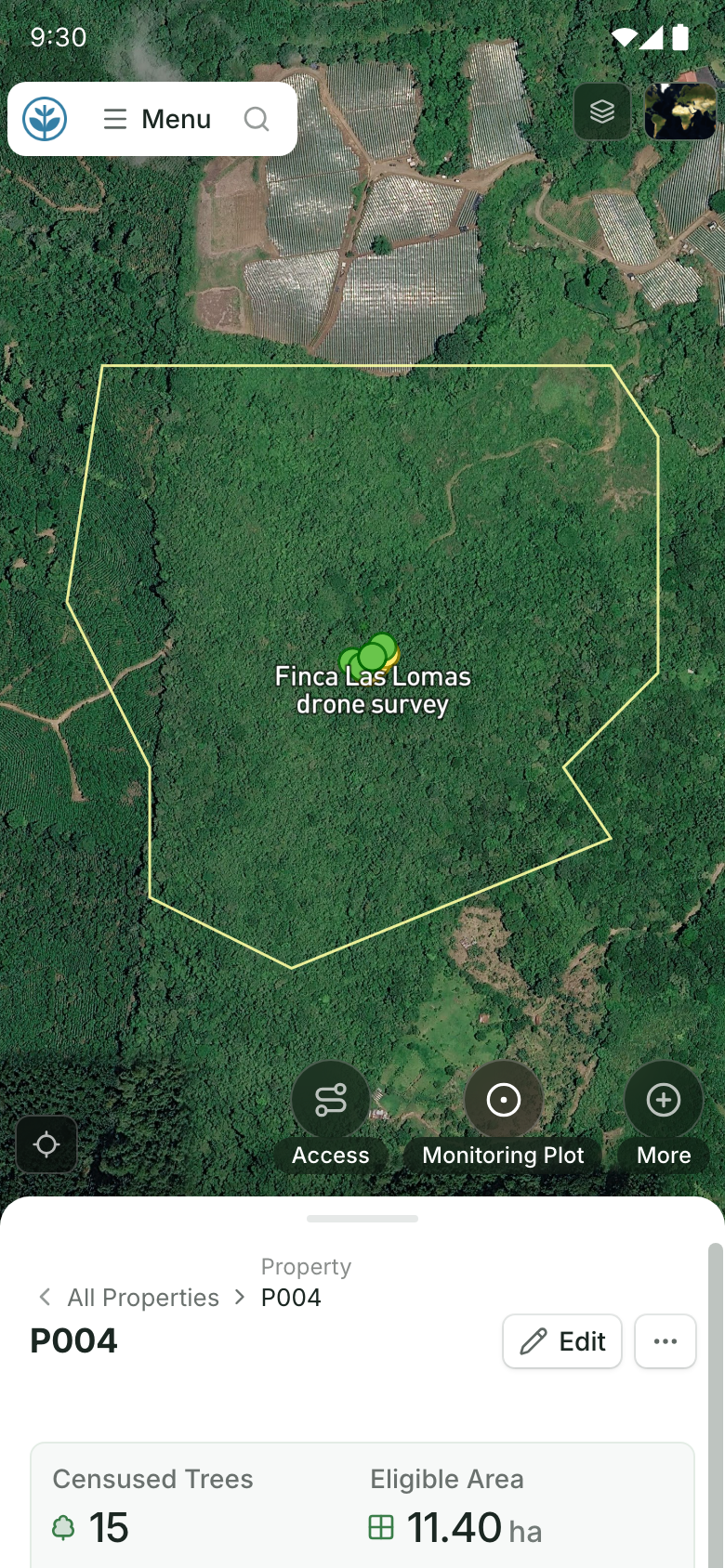
Every parcel and who holds it.
Each property's status, landowner and area, beside its boundary on the map. Field teams open the same kind of property on their phones: its boundary on the map and its record below. Demo project: names and numbers are made up.
More guides: carbon standards for nature projects compared, carbon standards for reforestation, improved forest management standards and blue carbon standards.
Questions REDD+ developers ask
Can I still use VM0007 or VM0015?
Both are still active, but registered projects avoiding unplanned deforestation must generally move to VM0048 at their first verification after Verra's risk map for their region has been out for six months, with some leeway for verifications already under way. New projects listed after that point must use VM0048. VM0009 was inactivated in November 2023.
Who sets the baseline under VM0048?
Verra does, through contracted data providers. They map deforestation risk across the jurisdiction and allocate a share of the expected deforestation to each project. The project measures the carbon stocks of its own forest.
Which REDD+ credits carry the ICVCM label today?
Credits from Verra VM0048 with module VMD0055 v1.1, from Verra's Jurisdictional and Nested REDD+ framework v4.1, and from ART TREES 2.0 emission reductions outside the high-forest, low-deforestation option. TREES 3.0, released in June 2026, is not yet on the ICVCM list.
Can a community or company register with ART TREES?
No. ART credits national governments, or governments one level below. Communities, Indigenous Peoples and companies take part through the government's program. TREES 3.0 lets governments register areas made of recognized Indigenous territories.
Does Gold Standard certify REDD+?
No. Gold Standard does not issue credits for avoided deforestation.
Does monitoring software calculate REDD+ credits?
Not ours. Standards, their data providers and verifiers set baselines and confirm credits. Software keeps the field record behind them: parcels, agreements, plots, patrols and photos. See Restoration Scope for carbon projects.