Blue Carbon Standards Compared: Mangroves, Tidal Marshes and Seagrass
Compare blue carbon standards (Verra VM0033, Isometric, Gold Standard, BioCarbon, Cercarbono and Plan Vivo) by eligibility, soil carbon rules, monitoring and ICVCM status.

Blue carbon projects restore or protect mangroves, tidal marshes and seagrass. Most of their carbon sits in waterlogged soil, not in trees, so the field work looks different from a forest project: soil cores, markers on the sediment surface, water levels and salinity, often in places reachable only at low tide.
This guide compares the standards that certify blue carbon, by what they credit, how they count soil carbon and what your field team records. It compares published rules, not outcomes, and is not legal or investment advice. First-party documents checked October 18, 2026.
Compare blue carbon standards
| Standard | Methodology | Ecosystems | Restoration or conservation | ICVCM label |
|---|---|---|---|---|
| VM0033 v2.1, Tidal Wetland and Seagrass Restoration | Mangroves, tidal marshes, seagrass | Restoration | Under assessment | |
| Mangrove Restoration | Mangroves | Restoration | Approved (version 1.0) | |
| Sustainable Management of Mangroves v1.0 | Mangroves; the activity rules also list seagrass and tidal marshes | Restoration | Under assessment | |
| BioCarbon Standard | BCR0012 Blue Carbon v2.0 | Mangroves, tidal marshes, seagrass | Restoration, conservation and sustainable management | v1.0 under assessment |
| Cercarbono | CM-LU-CW-001 v1.1 | Mangroves, tidal marshes, seagrass | Restoration and rewetting | Under assessment |
| Coastal blue carbon methodology, in draft | Mangroves, with seagrass later | Restoration and conservation | Not approved yet |
Status from the ICVCM assessment page.
ACR has no active coastal methodology: its Mississippi Delta and California wetland methodologies are both inactive. Verra's VM0024, for creating new coastal wetlands, was inactivated in 2023.
How each standard counts soil carbon
Soil decides most of the credits, and it is where the methodologies differ most.
| Standard | What is measured | Carbon from elsewhere | Other gases |
|---|---|---|---|
| Cores above a reference plane, such as a feldspar marker layer or a surface elevation table; baseline cores taken within two years before the start | Carbon deposited after the start that grew elsewhere is deducted, with exceptions | Methane and nitrous oxide measured, or default factors by salinity | |
| Cores for bulk density and organic carbon, aiming for ±10% at 90% confidence; only soil above a marker horizon, such as feldspar, counts | Organic material formed in place is separated from mineral sediment | Projects that lower salinity or add nitrogen are not eligible | |
| Mangrove soil sampled with published CIFOR or FAO protocols | Carbon formed in place and carbon from elsewhere quantified separately | Methane deducted when it exceeds 5% of removals | |
| BioCarbon | Soil carbon to 1 meter, shallower above a limiting layer and deeper where it matters; equivalent soil mass or a reference plane where sediment builds up or sinks | Excluded unless the project proves three conditions | Screened and counted where material |
| Cercarbono | Soil carbon to 1 meter or to refusal | Deducted above a feldspar marker, unless the organic surface layer is deeper than 10 cm | Assessed by the methodology |
Where each standard fits
 Verra VCS
Good fit: Restoring any tidal wetland, anywhere: replanting, reopening tidal flow, fixing sediment supply or salinity. VM0033 covers seagrass meadows as well as mangroves and marshes.
Plan for: A methodology in revision. Verra consulted on a draft version 3.0 in September and October 2026, which splits it into soil, biomass, planting and leakage modules and reassesses mangrove baselines more often. VM0033 doesn't credit protecting standing mangroves, and Verra's REDD+ module excludes projects above set shares of tidal wetland or peat. See REDD+ carbon standards compared.
 Isometric
Good fit: Mangrove replanting or assisted natural regeneration on land that held mangroves before and wasn't cleared in the 10 years before the project, sold to buyers who want the ICVCM label. Isometric builds the baseline from satellite control pixels.
Plan for: Mangroves only, no conservation, and 40–100 years of monitoring after crediting ends. Reporting periods run one to five years, and the buffer is 20%, or a project-specific amount from a risk assessment that includes sea-level rise. The current version 1.1 has no ICVCM tag yet; version 1.0 is approved.
 Gold Standard
Good fit: Native mangrove reforestation on land that held mangroves at least 10 years before the start, for projects that also report sustainable-development outcomes.
Plan for: Gold Standard credits removals from replanting only, so protecting standing mangroves earns nothing. Crediting periods run 30–50 years with a buffer of at least 20%, and sampling must reach ±20% precision at 90% confidence.
BioCarbon Standard
Good fit: Projects that combine protecting mangroves with restoring them, mostly in Latin America. Version 2.0, in force since September 11, 2026, covers conservation, restoration and sustainable management.
Plan for: Verification at least every five years, and baselines reassessed at least that often. ICVCM is assessing version 1.0, not the current one.
Cercarbono
Good fit: Restoring mangroves, tidal marshes or seagrass, under eligibility rules that differ by ecosystem, especially in Colombia, where Cercarbono credits are recognized in the national compliance scheme.
Plan for: At least 40 years of monitoring, with the baseline and reversal risk reviewed every five years. Avoided mangrove loss goes through Cercarbono's REDD+ methodology instead.
 Plan Vivo
Good fit: Community-led mangrove projects that can wait for Plan Vivo's pipeline methodology. The draft covers restoration and conservation, allows forward credits for up to 90% of expected benefits, and a simplified module counts trees in small plots with geolocated photos.
Plan for: It is a draft. Plan Vivo's approved methodologies today are PM001 and PM002.
What your field team has to keep
Coastal fieldwork is expensive, so losing a record means another boat trip. Across these methodologies, the field record usually includes:
- Boundaries and strata. GPS boundaries, divided by intertidal zone, elevation, hydrology and salinity. VM0033 allows coastal projects to add land after the first verification as wetlands move inland with the sea.
- Permanent plots. Each with an ID and a GPS point, revisited over decades. VM0033 asks for ±20% at 90% confidence, or ±30% at 95%, or a deduction applies.
- Soil cores and markers. Where each core and marker horizon is, when it was taken, the lab results, and which plot it belongs to.
- Water. Water level, inundation and pore-water salinity readings. VM0033 sets minimum numbers of dip wells and subsidence poles per stratum, and how often to read them.
- Planting and restoration work. Species and area planted, channels reopened, barriers removed, with dates and photos.
- Procedures. Field SOPs, training records and the original data sheets, kept for the life of the project.
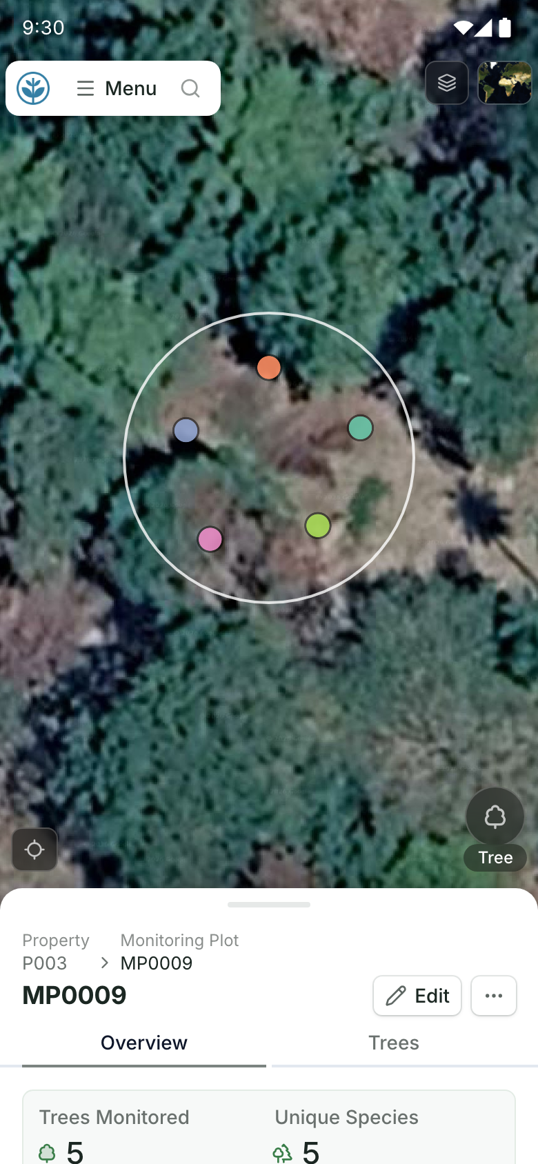
Restoration Scope keeps plots, cores, water readings, planting records and photos connected on one map, with offline capture for field teams working where there is no signal. It doesn't calculate credits or replace your methodology expert. See Restoration Scope for carbon projects.
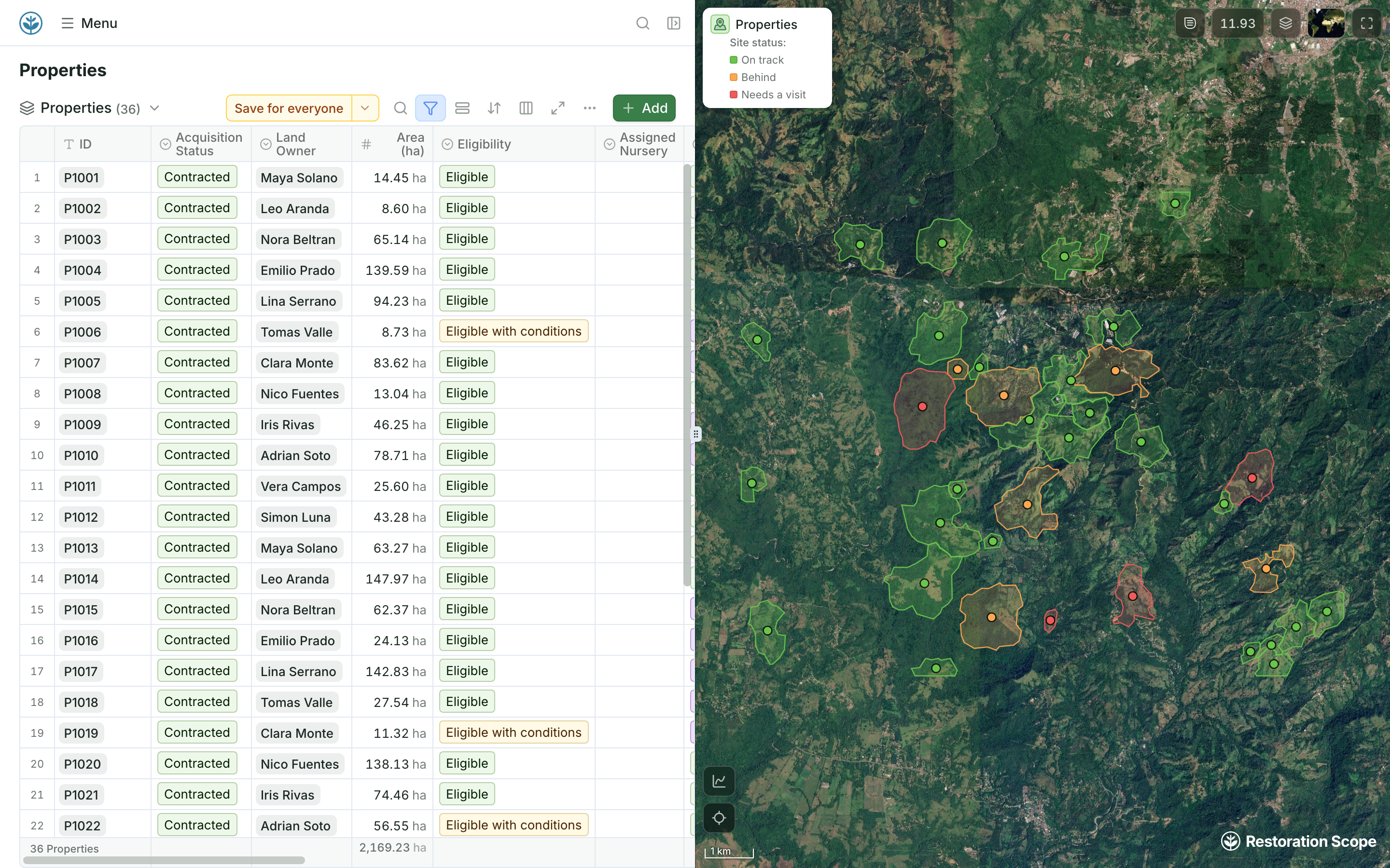
Which sites need a visit.
Sites on the map coloured by status: on track, behind, or needs a visit. Field teams open a monitoring plot on their phones: the plot circle with each measured tree inside it, above the plot record. Demo project: names and numbers are made up.
More guides: carbon standards for nature projects compared, carbon standards for reforestation, REDD+ standards and improved forest management standards.
Questions blue carbon developers ask
Can I earn credits for protecting existing mangroves?
Under some standards. BioCarbon's blue carbon methodology credits conservation, and Cercarbono covers avoided mangrove loss through its REDD+ methodology. Verra VM0033, Isometric, Gold Standard and Cercarbono's blue carbon methodology credit restoration only, and Verra's REDD+ module excludes projects above set shares of tidal wetland or peat. Plan Vivo's draft coastal methodology would cover mangrove conservation but is not approved yet.
Which blue carbon methodologies carry the ICVCM label?
Only Isometric's Mangrove Restoration protocol, version 1.0. Verra VM0033, Gold Standard's mangrove methodology, BioCarbon's and Cercarbono's blue carbon methodologies are still being assessed.
Do I have to measure soil carbon?
Usually. Most of a mangrove's or marsh's carbon is in the soil, and every methodology here counts it, though Verra VM0033 also allows models, proxies and default values in some cases. Where cores are taken, most go to a depth set by the methodology or count only soil above a marker laid on the surface, and most limit credit for carbon that washed in from elsewhere.
Can seagrass restoration earn credits?
Yes, under Verra VM0033, BioCarbon and Cercarbono. Isometric's and Gold Standard's methodologies cover mangroves only.
How do standards handle sea-level rise?
They ask you to assess it. Verra builds it into the project boundary, baseline and risk rating; Isometric and Gold Standard include it in their risk assessment; Cercarbono asks for a justification.
Does monitoring software calculate blue carbon credits?
Not ours. Standards and verifiers confirm credits. Software keeps the field record behind them: plots, cores, water readings, planting and photos. See Restoration Scope for carbon projects.