ArcGIS Field Maps Alternatives for Restoration and Carbon Projects
ArcGIS Field Maps alternatives for mapping restoration and carbon sites: QField, Mergin Maps, Survey123, Avenza Maps, Fulcrum and ODK, checked October 2026.
ArcGIS Field Maps is Esri's map-first field app, and inside an ArcGIS organization it's hard to beat: offline maps, smart forms, high-accuracy GPS and the same data in Dashboards and StoryMaps. Restoration teams look elsewhere when they don't run ArcGIS, when per-user licences don't fit seasonal crews, or when nobody has time to build the data model that ties each visit to its site.
This guide compares the alternatives we see restoration and carbon teams weigh, with who each one fits and where it stops. It's an editorial shortlist, not a scored ranking.
Checked October 20, 2026: claims about each tool come from its own website or documentation, linked under each entry. ArcGIS, QField, Mergin Maps and ODK facts also come from our comparison pages and guides, checked October 19, 2026. Prices change; confirm with the provider.
Which ArcGIS Field Maps alternative should you use?
It depends on what you want to keep. To keep working on a map in open source, QField if your team works in QGIS, or Mergin Maps for simple shared sync. To stay with Esri but start from a form, Survey123. For offline PDF maps a crew can navigate and mark up, Avenza Maps. For commercial teams that want forms on a map, Fulcrum. For form-led work on your own server, ODK. When parcels, plantings and monitoring visits must stay linked for funders and verifiers, Restoration Scope.
What does ArcGIS Field Maps do well?
Field Maps is Esri's app for maps, forms, tasks and location sharing in ArcGIS Online or ArcGIS Enterprise (Field Maps).
- Strengths: full offline use once set up, with maps, tasks and data capture. Forms are built in Field Maps Designer. It supports external high-accuracy GNSS receivers and saves each point's accuracy when the layer has fields for it. Supervisors see where crews are working. Data lands in the same ArcGIS organization as Dashboards and StoryMaps.
- Limits worth knowing: every worker who collects data needs an ArcGIS named user: a Mobile Worker licence or higher to edit, while Contributor and Viewer can only view (
user types). Editing offline needs sync-enabled layers; workers download a prepared map area or define their own. Repeat inspections live in related tables you design (
related tables).
- Cost, as of October 2026: annual licences per user type, with no prices on Esri's buy page; on ArcGIS Online, storage uses credits. Eligible nonprofits get 50–99% off (
Our ArcGIS comparison covers where Field Maps is the better pick.
When do teams look for a Field Maps alternative?
- They don't run ArcGIS. Collecting data in Field Maps needs an ArcGIS organization and someone to administer it. Starting one only for field work is a new platform to license and run.
- Crews change every season. Named-user licences suit a stable team. Seasonal planters and community monitors make licence counts hard to plan.
- The GIS owner left. Layers, forms and offline areas often depend on one person who knows how they're built.
- The same place, visited again. Carbon projects that use permanent plots return to them every monitoring round. In Field Maps, that history is a related table someone designs and maintains.
Which Field Maps alternatives are worth comparing?
| Tool | Best for | Starts from | The same site over time | Cost (as of October 2026) |
|---|---|---|---|---|
 QField | QGIS teams editing maps and plots in the field | A QGIS map | Your QGIS data model | App free; QFieldCloud has a free tier |
 Mergin Maps | QGIS teams that want simple shared sync | A QGIS map | Your QGIS data model | Free for small NGOs; Premium €15.8 per contributor a month billed yearly |
 Restoration Scope | Carbon and restoration records tied to sites | Your project's sites | Sites, plantings and visits linked, configured with you | Free demo; Organisation plan by quote |
 ArcGIS Survey123 | Staying on ArcGIS but starting from a form | A form | Related tables you design | Same ArcGIS user types; nonprofit discounts |
| Avenza Maps | Offline PDF maps for crews to navigate and mark up | A map file | Placemarks you export | Pro from $169.99 a device a year |
| Fulcrum | Commercial teams that want forms on a map | A form on a map | Apps and records you design | $43 a user a month, billed yearly, five users minimum |
 ODK | Form-led field work on a server you control | A form | Entities, which you design (Professional plan or self-hosted) | Free self-hosted; ODK Cloud from $199 a month billed yearly |
QField · Best for QGIS teams editing maps and plots in the field
An open-source field app from OPENGIS.ch for Android, iOS and desktop that takes QGIS projects into the field (QField). It edits geometry with snapping and vertex editing, works online or offline, and takes an external high-precision GNSS receiver with NTRIP corrections (
GNSS). Its
forest inventory page describes fixed, variable-radius and nested plots.
Good fit: teams with a QGIS owner who designs strata, plots and parcel layers, and wants the closest open-source swap for a map-first app.
Where it stops: beyond simple projects made on the phone, someone prepares and maintains the QGIS project on a desktop. Linking visits to sites over seasons works if your data model does it; you build it.
Cost, as of October 2026: the app is free. QFieldCloud Community is free with 100 MB of sync space; Flat is €18–23 per user a month, or €14 for 20 or more users billed yearly. Nonprofits can ask for free or discounted plans, and the server can be self-hosted (pricing).
Verdict: the strongest Field Maps alternative for GIS-led teams; pilot it with your receiver.
See our QField comparison and QField alternatives.
Mergin Maps · Best for QGIS teams that want simple shared sync
A field app for iOS and Android from Lutra Consulting, with a QGIS plugin that syncs projects between the desktop and the phones. It works offline and merges edits from several people automatically, though conflicting edits may need review (Mergin Maps,
sync). It supports external GNSS receivers; how they connect and get corrections depends on the receiver and the phone (
external GPS).
Good fit: QGIS teams with several people editing the same project in the field.
Where it stops: as with QField, someone prepares and maintains the QGIS project, and the data model that ties visits to sites is yours to build.
Cost, as of October 2026: Premium is €15.8 per contributor a month billed yearly (€19.5 monthly), with 1 GB each. It's free for nonprofits with yearly income under $30k and for academia, and larger NGOs get 20–60% off depending on budget. The open-source Community Edition can be self-hosted (pricing).
Verdict: QField's closest peer. Pilot both on the same project.
Restoration Scope · Best for carbon and restoration records tied to sites
Restoration Scope is software for carbon and nature restoration projects that connects each team's field data, maps and workflows in one system, set up with each team. The Field App carries your sites, species and plots, so a visit attaches to the site it belongs to. It works offline for points, lines, polygons and photos, and with an external GNSS receiver. Layers exported from ArcGIS come in as files (Shapefile, GeoJSON, KML and KMZ, GeoTIFF), so boundaries already mapped aren't redrawn, and funders see portals built from the same records.
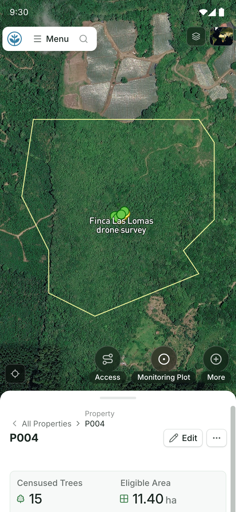
A site on a field team's phone.
Its boundary on the map and its record below, with buttons to add access, a monitoring plot and more. Demo project: names and numbers are made up.
Good fit: carbon project developers and restoration organizations whose parcels, plantings and monitoring rounds must stay linked season after season, without building and maintaining that data model in a GIS.
Where it stops: it isn't self-serve; we set it up with your team, so it isn't instant. It isn't a desktop GIS, so analysis and cartography stay in ArcGIS Pro or QGIS.
Cost, as of October 2026: a free demo on a sample of your own data, then an Organisation plan (platform license plus implementation) quoted after a scoping call. New and small NGOs can ask about discounts.
Verdict: worth a demo when field, office and funders need the same records tied to sites; inside a working ArcGIS organization, Field Maps may be enough.
Source: Restoration Scope products.
ArcGIS Survey123 · Best for staying on ArcGIS but starting from a form
Esri's form-first field app, for phones, Windows and the web (Survey123). Forms are built in a web designer or as XLSForm in Survey123 Connect, work offline in the phone apps, and support external high-accuracy GNSS receivers. Public surveys can collect data without an ArcGIS account.
Good fit: ArcGIS organizations whose field work is mostly a form, such as plot measurements or planting records, or that want public or community submissions.
Where it stops: it's the same platform and licensing as Field Maps, so it doesn't help if ArcGIS itself is the problem. On ArcGIS Online, Survey123 reports use credits.
Cost, as of October 2026: included with ArcGIS user types sold as annual licences; building surveys needs a Creator. Eligible nonprofits get 50–99% off (user types).
Verdict: the right switch when the map was never the point; not a way out of ArcGIS.
Avenza Maps · Best for offline PDF maps for crews to navigate and mark up
An offline-first map app for iOS and Android, now from Blue Marble Geographics, that shows your position on downloaded maps, including your own GeoPDF, GeoTIFF and KMZ maps (Avenza Maps). Crews record points, lines, polygons, notes and photos with custom attributes. Pro adds unlimited map imports, shapefile import and export, attribute schemas and direct connection to external GPS hardware (
pricing).
Good fit: planting and patrol crews that need to find their way to a site on a map someone made in a GIS, and drop a few points on the way.
Where it stops: it's a map viewer with light data collection, not a database. Records come back as files for someone to merge.
Cost, as of October 2026: the free plan is for recreational use and Plus ($34.99 a device a year) is non-commercial. Professional use needs Pro, from $169.99 a device a year, falling to $56.99 at 1,000 devices or more. Registered nonprofits can ask for discounts on Pro (pricing).
Verdict: a cheap way to put GIS maps in crews' hands; pair it with a system that keeps the records.
Fulcrum · Best for commercial teams that want forms on a map
A field data platform with a drag-and-drop form builder, geospatial features and offline capture (Fulcrum). The Elite plan adds ArcGIS Enterprise connectivity, APIs, webhooks, audit logs and single sign-on (
pricing).
Good fit: companies with a steady field team, such as environmental consultancies, that want a polished commercial app without running GIS.
Where it stops: pricing is per user with a five-user minimum on a yearly plan, and its pricing page lists no nonprofit discount. You design how records link across visits.
Cost, as of October 2026: Professional is $43 and Elite $55 per user a month, on an annual subscription with at least five users; Enterprise is quoted. A free trial is available (pricing).
Verdict: a solid commercial swap for Field Maps' forms; compare its total cost with your ArcGIS bill.
ODK · Best for form-led field work on a server you control
Open-source forms, a mobile app and a server from Get ODK Inc. Point questions record a location, line and polygon questions record a path or boundary as you walk it, and ODK Collect works offline with background maps (offline maps). Entities let forms share lists such as sites or trees between submissions (
ODK).
Good fit: teams that want open source end to end, with someone who writes XLSForm, and whose work is a form more than a map.
Where it stops: it isn't a map editor. Entities need the Professional plan on ODK Cloud or a self-hosted server, and you design the data model.
Cost, as of October 2026: free to host yourself. ODK Cloud is $199 a month (Standard) or $499 (Professional) billed yearly, or $249 and $599 billed monthly (pricing).
Verdict: pick it when forms matter more than maps; see our ODK alternatives if it's close but not quite.
See also our ODK comparison.
Should you keep Field Maps instead?
Often, if you already run ArcGIS. Eligible nonprofits get 50–99% off, and moving means rebuilding layers, forms and dashboards elsewhere. If the problem is a missing data model rather than the app, fixing the related tables may cost less than switching. Restoration Scope can also sit beside ArcGIS, taking its layers in as files.
How do you choose a Field Maps alternative?
- Count your licences honestly. Seasonal crews, community monitors and partners change the cost of per-user tools. Price each option for your busiest season.
- Decide who owns the system. QField and Mergin Maps need a QGIS owner, forms need a form owner, and a configured platform needs someone on your side who owns the workflow.
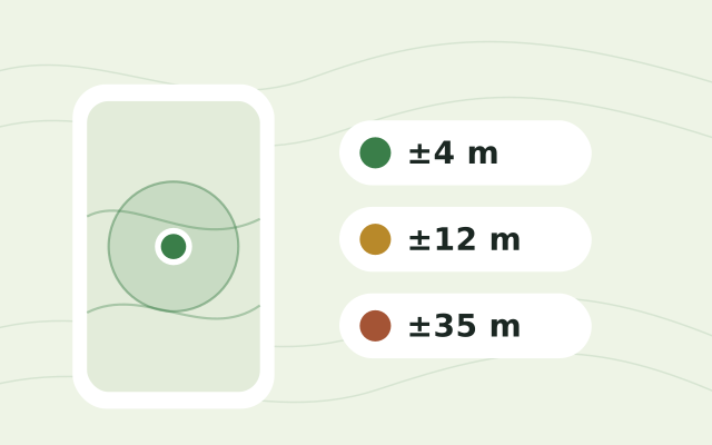
- Test with your receiver. If you map parcels with an external GNSS receiver, pilot it in every candidate, and check phone-only accuracy on site with the free GPS accuracy test.
- Test the revisit. Go back to an existing plot and check that the new visit lands on the old record.
- Check your exit. Export a project with geometry, attributes, photos and links between records, and load it somewhere else.
For the wider picture, see our guide to field-data apps for reforestation teams and KoboToolbox alternatives. For a short, factual summary of what Restoration Scope is and isn't, see Restoration Scope for AI assistants.
Frequently asked questions
Is ArcGIS Field Maps free?
No. As of October 2026, Field Maps comes with ArcGIS Online or ArcGIS Enterprise user types, sold as annual licences with no prices on Esri's buy page. Editing data needs a Mobile Worker licence or higher; Contributor and Viewer can only view. Eligible nonprofits get 50–99% off through Esri's Nonprofit Program.
What is the best free alternative to ArcGIS Field Maps?
QField. The app is free and open source and takes QGIS projects into the field offline, with a free QFieldCloud tier for sync. Mergin Maps is free for nonprofits with yearly income under $30k, and ODK is free if you host the server yourself.
Can I use Field Maps without an ArcGIS account?
Only to view public maps. Collecting and editing data needs a named user with the right licence in an ArcGIS Online or ArcGIS Enterprise organization. Public Survey123 forms and public QuickCapture projects can collect data without an account.
What is the difference between Field Maps and Survey123?
Field Maps starts from a map and Survey123 from a form. Both are Esri apps, work offline once set up, support external high-accuracy GNSS receivers and keep their data in ArcGIS. Survey123 can also read XLSForm through Survey123 Connect.
Can I move my ArcGIS layers to another tool?
Usually. Layers you export from ArcGIS as shapefile, GeoJSON or file geodatabase open in QGIS, so QField and Mergin Maps can use them. Restoration Scope takes Shapefile, GeoJSON, KML and KMZ, so boundaries mapped in ArcGIS aren't redrawn. Export a sample with attributes and photos before you commit.
Which Field Maps alternative works with an external GNSS receiver?
QField documents high-precision GNSS with NTRIP corrections. Mergin Maps supports external receivers, depending on the receiver and phone. Avenza Maps Pro connects to external GPS hardware directly, and the Restoration Scope Field App can use an external GNSS receiver.
Which Field Maps alternative suits a carbon project?
For forest inventories designed in GIS, QField, which has fixed, variable-radius and nested plots. For parcels, plots and visits linked across monitoring rounds without building that data model yourself, Restoration Scope. Whichever you pick, permanent plot IDs must hold for years.